Council adopts new local spatial plans to guide development and land use in Mamre
26 April 2023
The
City of Cape Town’s Council approved the Local Spatial Development Framework
(LSDF) for Mamre at its meeting today, 26 April 2023. The LSDF will guide
spatial development and land use management on a local level and provides an
overall spatial vision for Mamre. The City concluded the public engagement
process for the LSDF at the end of 2022.
'With the help and input from the Mamre community, the City's Spatial Planning Department crafted a vision for future developments in Mamre and the surrounding area. By adopting this LSDF, Council aims to promote and accelerate development and investment in the town of Mamre as the LSDF provides residents and potential investors with certainty for planning purposes. The LSDF will guide and to some extent could fast track the City's decisions when we assess development and land use applications for Mamre. We have consulted the residents of Mamre and presented the proposals. I am confident that this spatial planning tool has already sparked fresh hope and confidence in the future of the town and the possibilities for new developments. We want Mamre to become a town that is more sustainable, resilient and efficient in the years that lie ahead.
'There is an opportunity to strengthen Mamre as a gateway into the city from the north by enhancing the sense of place, and making it a tourist friendly destination. The vision is that future developments and investments use the identified six precincts as a guideline to build a resilient future with a community that is integrated with its surrounding environment, given the variety of natural assets in Mamre,' said the City's Deputy Mayor and Mayoral Committee Member for Spatial Planning and Environment, Alderman Eddie Andrews.
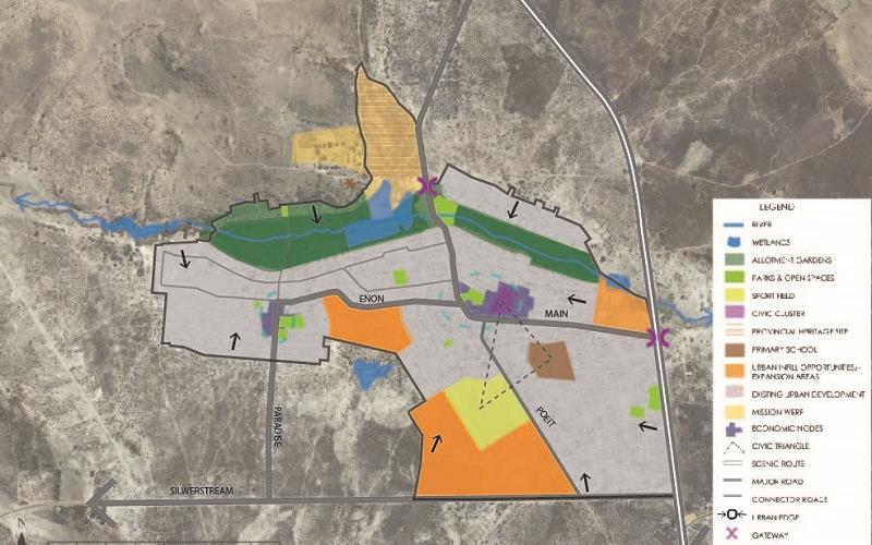
Six precinct areas have been identified for Mamre in the LSDF. These precincts are categorised according to its characteristics and functioning and include (amongst others) the river corridor, business areas, sensitive natural areas, road structure and functioning, as well as the urban development within the town. The LSDF further provides guidance in terms of the most appropriate land uses together with the principles that should be considered for development within each of these areas.
The LSDF precincts are as follows:
- Mission Werf: The area represents the heritage conserve (die Mission Werf), with iconic structures such as the Moravian Church (1818), Die Bakhuisie (1700), Kupper House (1770) and the Watermill (1840) and is the 2nd oldest mission station in South Africa. On the western boundary of this area the Moravian cemetery is located. The site also includes historical remnants of the leiwater channels and water mill. This precinct is envisaged to accommodate:
- Restaurant/coffee shop
- Amphi-theatre
- Tourist accommodation
- Arts, crafts and locally produced merchandise shops
- Educational tours including Mamre Garden
- Cemetery Hill – footpath and picnic area
- Education facilities
- Allotment gardens: The area is rich in culture and history, with the Modder River running in an east-west direction through the centre/ core of this area. The following uses are promoted in this area:
- Urban agriculture
- Walking/Running trails
- Training facility for urban agriculture
- Existing urban area: The area consists of the existing urban footprint(built up) area making up the town of Mamre.
- Urban development including residential, retail, offices and public facilities
- Recreation : parks, Non-Motorised Transport routes
- Mix of uses
- Small scale businesses e.g. Home enterprises
- Economic nodes: The area stretches along the major transport and activity routes of Mamre namely Main Road and Enon Street. The area represents a strong rural character, as informal trading occurs in various locations within the area and is planned to accommodate:
- Formal business
- Informal trading
- Home occupations
- Pedestrian walkways
- Cycle routes
- Passive recreation
- Urban expansion areas: Various parcels of largely vacant land has been identified as opportunities for urban expansion. These include the land parcels at the entrance to Mamre nestled between Main Road and the river in the north. The other areas identified for infill development are located along Enon Street(between the existing residential development) and along Poiet/Silverstream Streets(adjacent to the sports fields). Uses that this area is planned to accommodate are:
- Residential(mixed market)
- Formal business
- Informal trading spaces
- Home enterprises
- Community facilities
- Recreation
Commonage and surrounds: The area comprises of mainly large areas of high potential agricultural land and conservation worthy biodiversity. A large portion of land has been transferred to the community of Mamre through the land reform process and is known as the Commonage. Uses that are promoted in this precinct are: - Agriculture
- Conservation
- Recreation : Trails
- Tourist facilities
- Environmental education
- Wind energy farming
'In practical terms, the approval of the Mamre LSDF means that should an owner or investor have proposals for development on a specific site, the LSDF will be consulted in order to assess if such proposal and the envisioned land uses are aligned with the City's spatial policies. In so doing, it will contribute towards the implementation of the development vision for Mamre. It also means that the City will make services available to accommodate the nature of and amount of development planned in the LSDF,' said Alderman Andrews.
The Mamre community initially requested the City to assist them with the provision of housing. Initial research in response to this request highlighted that there are various projects in either planning or implementation phase that has been initiated by various stakeholders within the Mamre town and surrounding area. The need for a holistic approach that would provide guidance for the future development vision for Mamre was subsequently identified.
The City facilitated a public engagement process for the compilation of the LSDF which started in November 2019. This was done through various platforms including workshops, meetings and open days. Stakeholders were invited and informed through various media channels and community organisations were requested. These efforts were then further supplemented with assistance provided by the Development Action Group(DAG) that facilitated additional community engagements in order to obtain inputs into the LSDF. The statutory 60 day commenting period ended in December 2021 to ensure stakeholders had sufficient opportunity to provide their inputs. All comments received from the public and internally were considered and where appropriate amendments have been made.
The Cape Town Municipal Planning By-Law, 2015 (MPBL, 2015) mandates the preparation of Local Spatial Development Frameworks (SDF) to align and give further effect to the municipal SDF and in this case the Blaauwberg District SDF by providing more detailed, local area planning.
End
Published by:
City of Cape Town, Media Office